
Making the most of our established transportation infrastructure is crucial for ensuring everyone has access to convenient, safe, and affordable mobility. This requires a multi-pronged approach that prioritizes accessibility, affordability, inclusivity, and safety while simultaneously minimizing reliance on personal vehicles traffic congestion. HCAOG works with various state and local agencies to accommodate all modes of transportation and in doing so improve safety, non-motorized transportation, transit, congestion, long-term sustainability and economic vitality
Partner Projects
HCAOG, the City of Eureka, and Caltrans District 1 partnered to develop a multimodal plan to accommodate all modes of transportation along the Broadway Highway 101 Corridor and, in doing so, improve safety, non-motorized transportation, transit, congestion, long-term sustainability and economic vitality. Visit the City of Eureka's Broadway Multimodal Corridor project webpage.
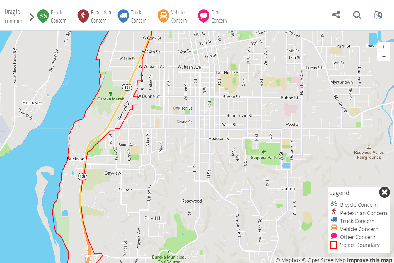
The objective of the Broadway Multimodal Corridor Plan was to develop a preferred concept with comprehensive multimodal improvement that address the corridor’s long-standing issues.
Ultimately, this Preferred Concept proposes new parallel and connecting transportation facilities that have the potential to enhance corridor safety, enhance multimodal connectivity, reduce corridor congestion, improve corridor reliability, plan for sea level rise, and expand access to coastal visitor destinations, essential local services, and regional commerce. In addition, the Preferred Concept with associated multimodal improvements highlights the priorities for the Broadway Corridor while positioning the corridor for funding opportunities. The Preferred Concept would create two one-way couplets to split northbound and southbound travel along two segments of the Broadway Corridor. Northbound travel would be accommodated along the existing alignment, and southbound travel would shift to an improved one-way Koster Street and a new one-way facility north of Vigo Street to Bayshore Mall. South Broadway would be improved with bike lanes and pedestrian safety improvements within the existing right of way.
The Preferred Concept will serve to guide future Broadway Corridor programming decisions. Additional collaboration, studies, and work are being done by the City of Eureka, Caltrans, and HCAOG to pursue improvements consistent with the Broadway Multimodal Corridor Plan.
Caltrans has already been approved to implement the complete-street improvements on South Broadway, including bike lanes, curb ramps, sidewalk, transit stops, pedestrian refuge islands, and flashing beacons. This project is now in design.
The Humboldt Bay Trail is a network of paved paths connecting the communities around Humboldt Bay. (See map below.) Efforts are actively underway to complete a continuous 14-mile, non-motorized trail from central Arcata to the southern end of Eureka, with future phases south to College of the Redwoods. This trail will increase road safety, provide a low-cost travel alternative, expand recreational opportunities, improve community livability, and promote active, healthy transportation. The trail is being constructed in phases by the cities of Eureka and Arcata, and Humboldt County, with support from Caltrans, the Great Redwood Trail Agency (formerly North Coast Railroad Authority), California Coastal Conservancy, and many other entities.
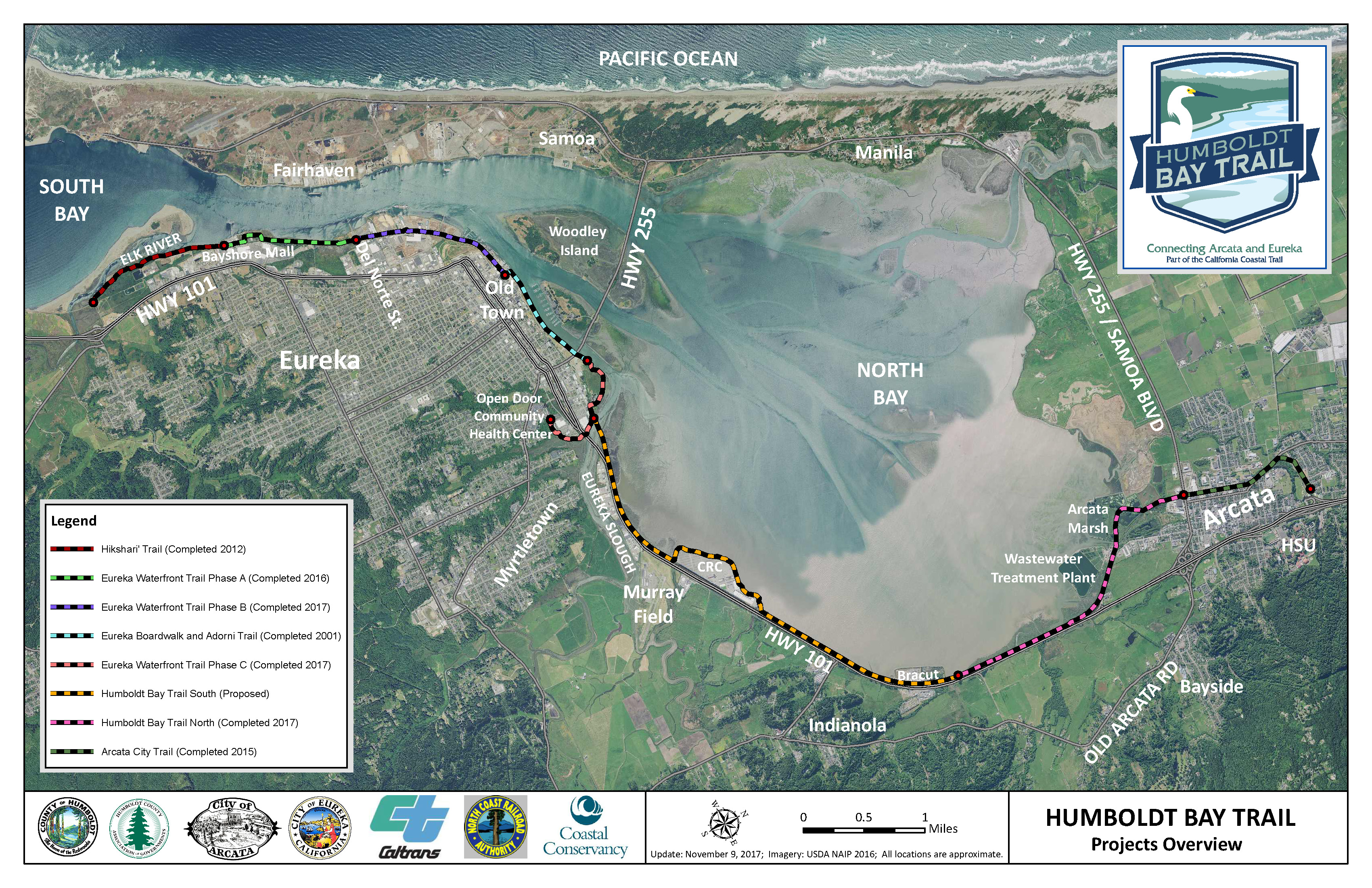
Construction on the four miles of the “Humboldt Bay Trail South” Project, which extends from the Target store near Eureka Slough north to the Bracut Industrial Park near Bayside Cutoff, begins in May 2023! That's Bike Month--how fitting! For additional information, visit http://www.humboldtgov.org/1923/Humboldt-Bay-Trail
The County of Humboldt has secured grant funds for preliminary trail planning for the envisioned continuation of the Humboldt Bay Trail from Eureka south to College of the Redwoods. Planning is slated for May/June to December 2023. (See previous planning work: Eureka-Scotia Trail Corridor Assessment (2016).)
-----------------------------------------------
The Great Redwood Trail links:
The Great Redwood Trail Agency https://thegreatredwoodtrail.org/
The Great Redwood Trail Master Planning Process (kicked-off in October 2022) https://greatredwoodtrailplan.org/
"Assessment of the North Coast Railroad Authority & Viability of a Great Redwood Trail" (background report prepred by State agencies for the State Legislature).
The Annie & Mary Trail is a proposed regional trail connecting the cities of Arcata and Blue Lake. The trail would generally follow the Mad River and former Arcata & Mad River Railroad Company corridor, with alternate alignments as needed based on geographic constraints. The Annie & Mary Trail is a collaborative effort between Humboldt County, City of Blue Lake, City of Arcata, Caltrans, Humboldt County Association of Governments (HCAOG), Blue Lake Rancheria, Redwood Community Action Agency, and Friends of the Annie & Mary Rail-Trail to develop a network of bicycle and pedestrian facilities between Arcata and Blue Lake.
Preliminary Right-of-Way Analysis – Part 1 (Streamline Planning 2014)
Preliminary Right-of-Way Analysis – Part 2 (Streamline Planning 2016)
Preliminary Trail Alignment – Railroad Avenue in Blue Lake (March 2018)
Overview Map – Blue Lake to Glendale (January 2018)
Preliminary Trail Alignment – Blue Lake to Glendale (January 2018)
The Little River Trail Feasibility Study (LRTFS), funded by the State Coastal Conservancy, analyzed potential non-motorized trail alignments from the southern end of Scenic Drive across the Little River to Clam Beach Drive. Creating a trail connection along this stretch of Humboldt County coastline would close a key gap in the California Coastal Trail (CCT) currently separating the communities of Westhaven and Trinidad from the Hammond Coastal Trail and Humboldt Bay communities. This trail connection to improve mobility options and recreational opportunities has been a priority for local residents, trail advocates and local and state agencies for almost three decades.
Little River Trail Feasibility Study (Final, April, 2014) (5.8 MB)
The City of Fortuna led this planning project, which evaluated how "friendly" and connected Highway 101, Downtown, and the Riverwalk Area are for multi-modal transportation. Focus areas are the 12th Street and Kenmar Road crossings of Highway 101 in Fortuna. The study included an evaluation of existing conditions, identification of existing facility deficiencies, and the development of conceptual alternatives.
Community meetings were held in March and July 2016. The Final Study Report was presented to the City of Fortuna City Council and to the HCAOG Board.
Fortuna Highway 101/Riverwalk Connectivity Study Report
Appendix B Environmental Constraints Analysis
Appendix C Review of Geometric Design Standards
Appendix D TAG Meeting Minutes
Appendix E Community Meeting Comments
Appendix H Truck Turning Analysis
Trails give people options for safe, active transportation and recreation and provide social, environmental, and economic benefits to our communities. Considerable effort is being made working toward the goal of a network of connected regional and local trails in Humboldt County. The purpose of this brochure is to highlight some of the accomplishments of the last five years and provide updates on trail projects currently being developed. In addition, this brochure identifies some of the challenges faced by trail projects and describes strategies being used by local agencies and organizations to deliver new trails for the public to use and enjoy.
Expanding Regional and Local Trails in Humboldt County - State of the Trails Report, June 2016